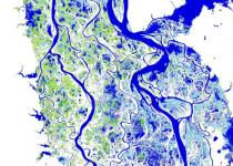
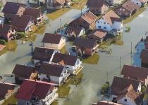
Earth's surface water is intensely dynamic. Water bodies change in size all the time, but these changes are not reflected on maps.
Human population is more concentrated than ever before. However, look at how many hours and sometimes days it takes to reach a major city from a remote area.
Our knowledge of the current extent of human settlements is incomplete. Luckily, we can now count on some help from above.
Experts at the JRC investigate potential threats that may affect Galileo, the European programme for a global satellite navigation system.
Satellites play a crucial role in understanding what is happening at sea.
Satellite data play an essential role in disaster risk management.
Satellite imagery helps assess and monitor the state of global land use over time. By comparing past and present images, we can get an overview of the evolution of land pressures.
Discover how EU scientists investigate how to prevent harmful electromagnetic interference on your portable devices, Wi-Fi access points and satellite navigation receivers.
JRC scientists develop tools and technologies that collect, analyse and make sense of a huge amount of information from various sources when disaster strikes.
How can we be sure that we have enough crops growing in Europe to feed us all?
About JRC Digital Media Hub
JRC Digital Media Hub helps you easily discover how the European Commission's Joint Research Centre (JRC) scientific research and advice are linked to our daily lives in the European Union.
You can explore our vast collection of animations, infographics, games, videos, virtual tours and other media by any science topic or Commission Priority according to your interests.
We are proud to tell about EU Science and open our doors to you. We invite you to explore and share our engaging digital content.
